One of the things that I find most interesting about having lived longer than two or three decades is the insight that MEMORY provides in keeping things like Weather (you know, high and low temperatures, blizzards, and rainfall) in perspective.
Case in point, the current heavy rainfall and resulting flooding in the Midwest.
COLUMBUS, Ohio (AP) - Residents warily watched as rivers continued to rise Thursday from heavy storms that dumped as much as a foot of rain in the Midwest and left behind more than a dozen deaths.
While the first day of spring brought much needed sunshine Thursday to Ohio and other states, authorities warned that many rivers would crest well above flood stage in the next several days.
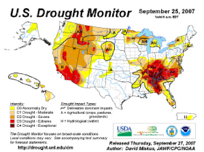
Ignoring the current headlines, I seem to recall reading stories like this one from October 2007 about record "global warming" induced drought.
Here's their featured graphic:

Anybody notice that big dark red "blob' there in the middle of the eastern half of the map?
Notice the states of Arkansas, Illinois, Indiana, Missouri, and Kentucky sitting there in water related distress?
And how's Ohio doing?
To find out, read along with me today...
Flooding also was reported Wednesday in parts of Arkansas, southern Illinois, southern Indiana, Missouri and Kentucky .(emphasis mine--VRR)
On Thursday morning, high water closed the eastbound lanes of Interstate 70—a major east-west highway—for about 4 miles in central Ohio's Licking County, the State Highway Patrol said. The flooding was receding by midmorning, but there was no estimate of when the lanes would reopen.
Morning commuters trying to reach downtown Columbus from the south were being detoured off heavily traveled U.S. 23, because its northbound lanes were flooded at Interstate 270.
President Bush declared a major disaster in Missouri on Wednesday night and ordered federal aid to supplement state and local recovery efforts in areas affected by flooding. Seventy counties and the city of St. Louis also are eligible for federal funding for emergency protective measures.
Several areas in Missouri were bracing for record-level flood surges expected to hit Friday and Saturday. Authorities were straining to keep pace with some of the worst flooding to hit their region in decades.
The National Weather Service was forecasting record flooding along the Meramec River near St. Louis. Some residents had already been evacuated Thursday. The Black, Big and St. Francis rivers in southeastern Missouri also were expected to see significant flooding.
The town of Fenton put out a call asking volunteers to help put down sandbags against the floodwaters Thursday. Gov. Matt Blunt said cities can count on the state for help as he activated the Missouri National Guard.
"Missourians should know that we are doing everything within our power to provide state resources to communities in need," Blunt said.
Much of Ohio was under a flood warning Thursday, with some areas cautioned to watch for flash floods. Most of southwest Ohio had received more than 4 inches of rain, and officials in Butler County declared a state of emergency because of the rising waters.
Again folks, I never mean to make light of the effects and suffering caused by weather and other "natural disasters. It's just that I insist on tempering my own excitement and enthusiasm with balance and understanding of the context of the situation I'm addressing.
I also feel compelled to want to point out how easy it is to get all worked up with the arrival of rain or snow, or the lack there of, then quickly forget the past in favor of lamenting the results of the current events.
Anyone that knows me knows that, when addressing our current rainfall shortages, I've recently been reminiscing about the drought that occurred here between 1987 and 1990, and continued to a lessor extent in the south and Midwest into the early 1990's (I remember because I was buying my first boat during that period) before the record setting Great Flood of 1993 inundated the Mississippi River from Minnesota to the Gulf of Mexico, in the end bringing things back to...
Get ready...
A V E R A G E Rainfall.
Get it?

2 comments:
You are aware that global warming predicts more extreme weather of all kinds -- which in fact we have been experiencing. Record flooding -- especially an increase in the percentage of rain that falls in 24-hour rain events -- is projected because the atmosphere will be holding more water.
At the same time, dry areas will get dryer, in part because of greater evaporation -- and in part because global warming causes the tropics and subtropics to expand. The subtropics tend to be where the deserts are.
Part of the world will turn to desert, and parts will be regularly flooded. On average, maybe not so bad, but in reality, a catastrophe for billions.
Thanks for the lucid comment Joe.
I appreciate your point of view, but I just don't agree that we have enough data to support your position yet.
Further, the computer models aren't accurate enough to do anything but stab at results that is "alarming" and "interesting", but still nothing more than coincidence or just plain dumb luck.
Post a Comment