As I’ve said many times before, I'm a self proclaimed rocket scientist, not a professional weather forecaster. I also often state that if I were 18 years old again and could start over in college I would consider studying meteorology instead of engineering. Then I could run around with the likes of Jim Cantori and make a fool of my self in front of a TV camera—all the time enduring 100 MPH winds.
Having made that admission, I have my own forecast for Wilma’s path and it doesn’t match the computer models. I’ve been wrestling with publishing my prognostications for a couple of days now, but I was afraid of looking STUPID so I’ve held my tongue and kept my fingers off of my keyboard regarding this issue. The only one I've told so far is my girlfriend, and she's getting all nervous as a result.
Here is what I think Wilma is going to do this weekend.
I think that she is going to continue on a north north-west track for longer than the forecast models are predicting. South florida is only in trouble if she makes a very abrupt turn.
As she moves further west, she is also going to delay the predicted turn back to the east. The further north she moves, the harder it is going to be for her to threaten the Florida Keys.
The result?
I think that Wilma will make landfall closer to Tampa than Naples. She might even move as far north as Cedar Key and the Suwannee River inlet up in the “big bend” area of Florida.
Why do I think this?
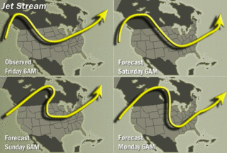
The jet stream--their whole predictions are based on where the jet stream is this weekend. That's bad news for the northern Florida pennesula because because the jet stream hasn’t behaved the way they were predicting it to behave earlier this week.
Here is the current Jet Stream forecast:
 See how the jet moves from running across northern Mississippi, Alabama, and Georgia on Saturday to passing over Illinois, Indiana, and Ohio on Sunday?
That isn’t what they were predicting earlier this week. The jet was supposed to dip low over the southern US, even dipping into the Gulf of Mexico, thereby grabbing the storm and slinging it off across south Florida and into the Atlantic to die.
Since the Jet Stream isn't as far south as predicted, I also think that Wilma will continue to move along rather slowly, so landfall could be late Monday or possibly sometime Tuesday, depending on how far north she moves.
As to the actual strength when Wilma finally makes landfall in Florida, I agree that it’s anybody’s guess—probably a 2 or a 3. A landfall further north could be a "double whammy" for all of the people from the Keys and the Ft. Meyers/Naples area that have already evacuated into central and norther Florida.
Can you imagine what a pisser it will be to have to move AGAIN for the same hurricane?
All I know is that I take a great deal of personal comfort because of all of the land that exists between the west coast of the Florida Panhandle and the south Georgia coast. The worst we could see here if she comes our way is a strong tropical storm or a very weak hurricane.
Remember, Y'all--you heard it here first.
(I'm gonna remind you too...)

No comments:
Post a Comment